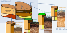
For the first time ever, soil profile data on soil maps of Germany are available at a scale of 1: 200 000. A temporary version of a factual database for soil maps can be downloaded at the product centre of BGR (Bundesanstalt für Geowissenschaften und Rohstoffe) when following this link: https://produktcenter.bgr.de/terraCatalog/DetailResult.do?fileIdentifier=154997F4-3C14-4A53-B217-8A7C7509E05F (the data link can be found under “Vertrieb”). Map’s graphics and the legend’s texts of currently 50 (out of 55) published map sheets have been available for a few years by now. The map is created by a cooperation of BGR and geological services of the federal states. It is published analogously as well as digitally. Currently another map sheet is in its completion. With the now available soil profile data, analysis on various themes can be made. The factual database for soil maps is relevant to the BonaRes Centre, because soil data and metadata from the public sector will also be included through the BonaRes Data Centre.