Germany’s first LTFE research data is published for free reuse.
The BonaRes Data Centre is pleased to announce the V140 LTFE has been made available for free reuse: https://doi.org/10.20387/BonaRes-BSVY-R418
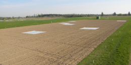
LTFE are essential research infrastructures for agricultural and soil sciences and fundamental for answering current and future research questions. Some LTFE run since a very long time; the start of the oldest still running LTFE in Germany was 1878. Therefore, valuable time series exist in many cases which can be utilized, for example, to model slow changes of soil parameters. In the context of BonaRes, field experiments are regarded as LTFE if they have a duration of at least 20 years and a static design. The Müncheberg "V140" LTFE was established in 1963 at the experimental site of the present Leibniz Centre for Agricultural Landscape Research (ZALF) about 50 km east of Berlin in the district Märkisch-Oderland. It represents one of the few still active long-term field experiments on sandy soil. The most common soil sub type is Haplic Luvisol. The experiment includes 21 treatments: 5 levels of mineral fertilization combined with 4 levels of organic fertilization and one control treatment. A relational database schema was developed for the experimental data in order to provide the data in a standardized format. The data set contains 32 parameters; among others: laboratory data of soil, plant samples, dates and application of sowing, fertilization and plant protection, used plant varieties and yield data. An essential prerequisite for the scientific reuse of LTFE data is the consistent use of national and international standards to describe the research data. Accordingly, parameters such as crop and variety, agricultural machines, methods and plant development stages have been standardized. In order to ensure the initial scientific exploitation of the research data by the data collectors (right of first use), the provision is delayed by a 9-year data embargo. Today data from 1963 to 2009 are available and will be extended annually. If more recent data are needed, please contact the data author. Access to the data is provided by the BonaRes Data portal (https://maps.bonares.de/mapapps/resources/apps/bonares) under the free license CC-BY.